


Recreation
Eagle Cap Wilderness
The Eagle Cap Wilderness, at 361,446 acres (556 sq miles) is Oregon’s largest. Within these white, salt-and-pepper granite mountains, you’ll find approximately 534 miles of developed trails and over 50 lakes to explore, including Legore at an elevation of 8,880 feet- Oregon’s highest.
Prior to the coming of the white man, this was all part of the homeland of the Niimipu (Nez Perce). They used this area primarily in the summer months for grazing their horses, hunting, fishing and the gathering of huckleberries and other plants. Most of the trails in use today were long established by the Nez Perce, although the Forest Service made switchbacks in certain places to deal with the steep terrain.
The ecosystems vary from cool, mixed fir & pine forests, to high alpine meadows. Almost everywhere you hike you’ll plenty of cold, clear water. Classic glacial cirque lakes are common with many that have both stocked and natural populations of Eastern Brook and Rainbow Trout. Elevations range from about 3,000 feet to 9845 feet (Sacajawea Peak) and there are 31 other summits exceeding 8,000 feet. The most popular area within the Eagle Cap is the Lakes Basin Management Area which caries some additional restrictions due to its popularity.
Trails vary from easy to difficult and most are rocky. Horses should be freshly shod and a temporary boot/shoe should always be part of your gear.
Wildlife includes Mule Deer, Elk, Mountain Goat, Bighorn Sheep, Pine Squirrel, Pica, Pine Martin, Mink, Beaver and River Otter. There are also Black Bear, Cougar, Coyotes, Red Fox and Wolves- though the chances of an encounter are rare and there is no record of any attacks in this area from any of the top predators.
While many are content to admire the beauty of these mountains from the outside, entering the core opens up an experience that totally upends the notion that ‘beauty is only skin-deep.’ Your appreciation of this National Treasure increases exponentially with every effort you make to explore farther into it.
See the USDA Forest Service, Eagle Cap page for more detailed information.
Hiking Around Joseph Oregon
The Joseph Oregon area has access to literally hundreds of miles of trails for hikers and horseman to discover and explore. In the Eagle Cap Wilderness you’ll find that most trails are rocky and moderately difficult. Casual hikers can find many miles of trails that offer exceptional scenic experiences as well. The stunning mix of varied landscapes and visual surprises is hard to completely cover in a lifetime.
To warm-up, consider some of the easier hikes: Iwetemlaykin, Wallowa Lake East Moraine Hike, Hurricane Creek and the trail to BC Falls at Wallowa Lake. Don’t overdue it on your first day; the effect of elevation on those used to living closer to sea level can affect you more than you think.
If you’re trying to cut your ascent to one of the many peaks or lakes, consider a trailhead that starts at a higher elevation to begin with- this can cut more than 1000 feet off your climb.
Also, short-cutting to into the Alpine Zone is just an incredible Tram ride away. On top there are trails to explore and the views are breathtaking (without all the panting).
When venturing into the more remote areas please be aware that even basic services are scarce and you’ll find cell coverage spotty at best. Plan to have plenty of gas and water for your trip!
Speeds on USFS gravel roads are slow, less than 25mph. The gravel roads can be harsh on soft/worn tires so do check your spare and plan extra time to your destination.
Joseph Area Trail Access (closest to farthest):
-
Iwetemlaykin State Heritage Site
- One Mile from Joseph (Natural, Oregon State Park)
- El: 4400′
- Improved- Smooth trails – Great for Runners
- Good Parking
- Features Short Nature Trail, Pond, Meadows, Wildlife, ADA
- No Pass Required
- East Moraine Trails
- 4 miles from Joseph (Natural, Community Forest, Multiple Use Area)
- El: 4450′
- Dirt Road and Rocky Trails
- Pass-free parking
- Features incredible views, Horseback and Bicycle roads
- No pass required
- Hurricane Creek Trailhead:
- 6 Miles from Joseph (Wilderness)
- El: 5050′
- Very Narrow Road (Blind Corners… GO SLOW)
- Good Parking
- Features Goat Meadows, Slick Rock, Lakes Basin
- NW Forest Pass Required*
- Wallowa Lake Trailhead:
- 7 Miles from Joseph (National Forest, Wilderness)
- El: 4675′
- Improved
- Good Parking
- Features Three Major Trails, Views, Streams Waterfalls, Lakes
- No Pass required
- McCully Trailhead:
- 11 Miles from Joseph (Wilderness)
- El: 5763′
- Narrow Road, Paved/Gravel Road
- OK Parking
- Features Two Trails, Back-Route up Mt. Howard and the trail to the beautiful McCully Basin
- NW Forest Pass Required*
- Tenderfoot Trailhead
- 24 Miles from Joseph (Wilderness)
- El 6514′
- Rustic
- Paved/Narrow Gravel Road
- Good Parking
- Features Bonny Lakes, Tenderfoot Pass, Dollar Ridge (fossilized seashells) and beyond
- No Pass Required
- Maxwell Lake Trailhead:
- 33 Miles from Joseph (Wilderness)
- El: 5450′
- Improved
- Long Paved/Gravel Road
- Good Parking
- Features Maxwell Lake
- NW Forest Pass Required*
- Two Pan Trailhead:
- 34 Miles from Joseph (Wilderness)
- El: 5590′
- Improved
- Long Paved/Gravel Road
- Good Parking
- Features easiest access to Lakes Basin
- NW Forest Pass Required*
* NW Forest Day-Passes are available at most trailheads by self-issue.
The Prairie of the Wallowas
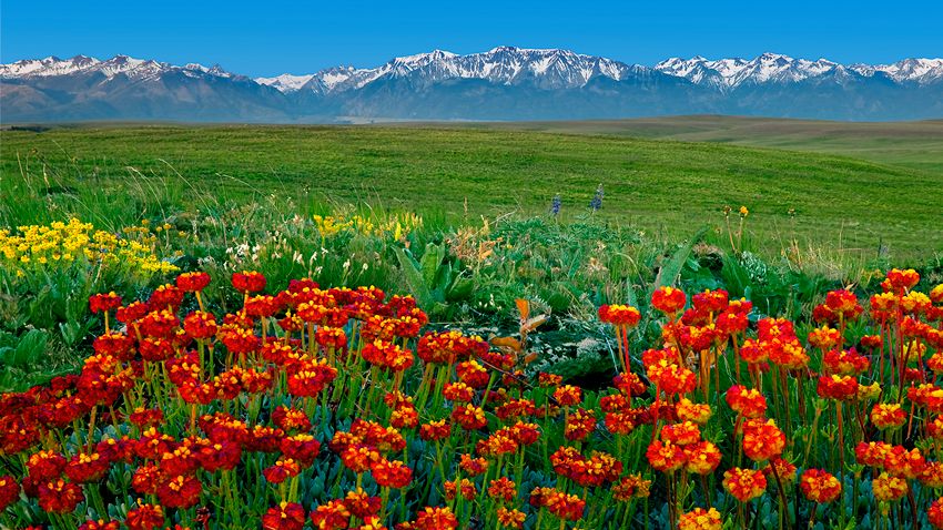
If you’re visiting for the first time, you probably came here for the mountains, but did you know that there’s a rare and spectacular feature that most never visit? It’s the vast, 515 sq. mile (329,600 acre) prairie known as the Zumwalt and its largely pristine and intact. It’s boundary extends northeast from all the towns in the Wallowa Valley right up to the forests that mark the rim overlooking the Snake River along the Oregon-Idaho border. This once-common landscape covered some 40 percent of the U.S, but today less that 2 percent remains. If you like rolling hills, vast skies, green fields and wildflowers, our prairie environs are sure to impress.
To the north of Joseph lays the heart of the Zumwalt Prairie.
The Nature Conservancy holds a significant portion that it considers to be the most pristine of its kind. A small holding within the preserve was even designated as a National Natural Landmark in 2013. To the east lays the Cats Back; a varied, high-mountain summer grazing area.
Both are similar and special in their own way:
- The area around the Preserve is fairly flat with three prominent hills.
- The Cats Back is divided by canyons and a long ridge.
- The Zumwalt Preserve has developed trails and a few of the trails have gentle grades making them perfect for a leisurely nature walk.
- The Catsback has only roads and makes a great place to explore on bike.
The Zumwalt Prairie Preserve

The Zumwalt Prairie once grazed the horses of the Nez Perce. It’s natural inhabitants were Elk, Deer and Buffalo. Today it’s mostly cattle, but sizable herds of Elk still roam the land where it’s not unusual to see as many as 200 at a time. Truth is, the prairie grass needs the grazers just as much as the grazers need the grass; in fact the Nature Conservancy relies on cattle to balance and maintain the preserve.

The preserve provides crucial habitat for endangered ground nesting birds. It also provides a home for one of the west’s largest populations of birds of prey.
The 33,000 acre preserve has four marked trails that are about 2 miles in length. Its a wonderful place to visit, particularly during the wildflower bloom in mid-April to late June.

Visit The Nature Conservancy Zumwalt Prairie Preserve site for more information.
Directions:
Getting there is pretty straight forward- Set your trip meter at the Joseph Market and head north on Hwy 82 (towards Enterprise) for 2.8 miles and turn right on Crow Creek/Eggleson Ln. Stay on this main/paved road for 5.2 miles till you get to the fork and stay right on to Zumwalt Road. The road will turn to gravel so slow down! The crushed rock in our area forms some wicked shapes (think arrowheads) and slowing down will help save your tires. From here on out you’re in the prairie. Continue another 14 miles just past Findley Buttes and look for the signs to the Zumwalt Prairie Preserve. The parking area has an information kiosk to help you decide which hike to take. Note: No horses, dogs or bicycles are allowed off the main public roads. Travel on trails is by foot only.
The Cats Back

Thirteen miles to the east of Joseph lays the Cats Back. This section of the prairie has an indescribable presence that many visitors are quite taken with- some even consider it their temple! It’s not hard to see why: with its open sky and twin mountain ranges, it certainly fits the description of God’s Country. It’s a quiet and lonely area- the perfect place to get that ‘peaceful, easy feeling.’ In the late 1800’s, the daughter of one of the only families to live on the Cats Back, claimed that if you stayed quiet long enough, you could hear the mountains sing. It’s easy to imagine her time long ago, so little has changed.

Exploring this location can be problematic, mainly because the road conditions vary. You should have good tires, including a good spare and a vehicle with decent clearance. Out further on the dirt roads you can expect to find impassible muddy sections during the wet months. Don’t drive off road and don’t make the mistake of thinking that your lower-clearance 4WD vehicle won’t become high centered if you fall into deeper ruts. Warning: if you get stuck, you might be there overnight! So, come prepared or better yet, just avoid this area until it’s had a chance to dry out. Cellphone coverage is also not guaranteed. While this area can be explored by vehicle, it makes an ideal mountain biking, horseback riding or hiking area.

While the roads are public, the land on all sides is private. During the summer months the area is used to graze livestock and at times you may find gates across the roads- if you open them to pass, just be absolutely sure you close them well. Leave any gates just like you found them!

Directions:
From Joseph set your trip meter and head east towards Imnaha on Hwy 350 for 8.9 miles then turn right on Rail Canyon Road. Proceed slowly on this gravel road; there are a few houses and the residences like their peace and quiet. You’ll come to a switchback that will ascend up a gradually less-improved road that can get pretty bumpy in places. It winds back down through some woods and heads back up again onto the prairie. By this time the road has changed its name to Armin and if you proceed further it will change again to Deadhorse Ridge Road. None of this will matter, as the roads have no signs anyway. Generally you just stick to the road most traveled. If your plan is to hike or mountain bike, anywhere along here would be a good place to pull off and proceed, if not you’ll eventually come to a small corral at the 15.5 mile mark. Proceed another quarter mile and you’ll get to a intersection where you can continue east along Deadhorse Ridge or you could turn north (left) towards Downey Lake.
The road east along Deadhorse Ridge continues another 11 miles until it just ends, and the northern route continues another 4 miles until it picks up Bear Gulch Road. Both are rocky in places and may have swampy spots that pose a real problem getting stuck.
Touring for Grand Views
The stunning landscape around Joseph Oregon is characterized by extremes of elevation. While most rightly associate the Joseph area with the mountains, a vast area is actually made up of canyons.
And our canyons aren’t just slight little things; they include the deepest gorge North America! Looking at a topographic map of the area reveals a very furrowed landscape- in fact if it weren’t for the higher mountains, Joseph might well be thought of as ‘Canyon Country.’
The forces were extreme! While the Eagle Cap and Seven Devils were literally lifted up off the sea floor (you can find sand dollar fossils on the mountain tops) the relentless forces of erosion were busy carving things in the opposite direction. The process continues to this day.
Northeastern Oregon’s eastern boarder is defined by the mighty Snake River/Hells Canyon, the deepest gorge in North America. The Seven Devils Range sits just across that border in Idaho and accentuates the elevation difference. Also cutting across the area are two other major canyons: Joseph Creek and The Imnaha, along with a multitude other smaller creeks that form canyons of their own.
The greatest canyon expanse can be seen at Buckhorn where the Imnaha converges with the Snake River to create an immensely vast and rugged landscape that stretches out for miles. It includes views of both the Devils and the Eagle Cap. It’s absolutely breathtaking, even if you have visited the Grand Canyon.
As you drive around the area you’ll notice a patchwork of tree sizes. This area, including all of the massive 652,488 acre Hell Canyon Recreation Area (HCNRA) is subject to lightning caused wildfires due to the convective (thunderstorm) activity generated by the heat in the canyons themselves. Fire has always been part of the area’s natural history and is a necessary ingredient for the health and indeed the survival of many of the species that have evolved on this land. After years of fire suppression, scientific study revealed the error in our ways and thankfully the Forest Service now practices prescribed burning in the HCNRA, returning the forest to a more natural, healthier state. Burning the ladder fuels helps to protect these forests from catastrophic wildfires that kill everything. It also creates park-like stands of Ponderosa Pine that are some of the most beautiful on the planet.
You could spend many days just touring for your favorite vista, but beware; while some are a Sunday drive, others are quite harrowing and might make you feel like you’re in one of those movies about Peru. So before you depart please consider the guides below and in all cases drive slow anywhere you can’t see around corners; it’s surprising just where you’ll encounter traffic or animals. Check your spare and come prepared with plenty of gas and water and don’t forget your camera!
Winter Recreation
Visiting Joseph during the winter might sound like a crazy idea, but it might be just the thing your peace-starved soul desires. And, it can be a lot of fun too!
Many would-be wintertime visitors avoid traveling here, assuming that Joseph’s all stuffed up under many feet of snow. That’s simply not true; except for the occasional strong winter storm, Joseph’s roads are always plowed and driveable. The highways in and out are regularly cleared as well. We can have several weeks of packed and snowy roads, but the temps are typically below 28 degrees, just where tires get a better grip. Check the road conditions here.
While winters in Joseph do slow you down, it really is a magical time of year. With almost no traffic and the snow absorbing most sound, you’ll be naturally lulled into a relaxed, unhurried pace. Winter here is a blissful ‘peace on earth’ -just like it should be.

Travel into the countryside and witness spectacular winter scenes complete with wildlife as many of the deer and elk are driven down into the valleys. Wallowa County also boasts a large population of wintering hawks and other various birds.
Ready for some casual fun? Go sledding up on Alder Slope; the traffic is light so almost any hill will do. Strap on some skis and take a leisurely jaunt around the local parks at Wallowa Lake or Iwetemlaykin. Throw on some snowshoes and hike up the West Fork or Hurricane Creek Trails. Please, always check the Wallowa Avalanche Center before taking to the backcountry.

Take a short drive southeast 9 miles to our community-run ski slope called Fergi, short for the Ferguson Ridge Ski Area. While it only has a T-Bar and Rope-Tow, the prices are low to match. This is a warm and friendly place with a small lodge and ski/snowboard rentals to boot. It’s a great place to learn to ski or snowboard. The gentle lower slopes are just perfect for the little ones.

A fun event of the spectator kind happens at Fergi in January and includes our furry friends. The Eagle Cap Extreme Sled Dog Race is a howling good bit of fun and excitement as Mushers and their teams head into the wild for the 200 mile, Iditarod-Qualifing race.

Want a real adventure? Further to the east of town you’ll find another winter recreational area called Salt Creek Summit. It’s near the Hells Canyon Recreational Area and adjacent to the Eagle Cap Wilderness. This area geared to the intrepid outdoor enthusiast where you’ll find something for every skill level, from beginner to extreme.
Salt Creek Summit is split with snowmobile trails on the east side and nordic/cross-country/snow-shoe trails on the other. Both sides offer marked, groomed or packed trails that extend for miles and miles. This can vary depending on snowfall, so check with the Wallowa Visitors Center first.

The snowmobile side has 175 miles of groomed trails and beyond that you’ll find other trails and roads that will allow you to travel as far as your skill and fuel will take you. The area is large enough to permit plenty of varied, uncongested riding through some of the most beautiful country in the world. Download this map for a better overview or download this big map for a to see all the designated snowmobile trails in Wallowa and Baker counties.
On the western side and across the access road #39, you’ll find nordic trails that lead south into wilderness. Or, you can go north and take a short loop or travel the Redmont Trail back down to the Fergi ski area. Download this map for an overview.
The Nordic Ski Club operates and rents a few ski huts in the Wing Ridge area for those looking for an overnight ski adventure. Visit their site for details.
About every 3rd year or so the Wallowa Lake freezes over. For whatever reasons, people just cant resist getting out on frozen water. Walking, skiing, skating, playing hockey and riding bikes are common activities. Ice fishing can also be very productive.
So next time you’re thinking about getting out of the rat race and into the outdoors, come to Joseph where you can do both!
Camping in Joseph Oregon and Surrounding Areas
Nestled in the breathtaking Wallowa Mountains of northeastern Oregon, Wallowa Lake State Park offers visitors an unparalleled blend of natural beauty and outdoor adventure. The park’s pristine lake provides a stunning backdrop for hiking, fishing, boating, and swimming, while its well-maintained campgrounds cater to both tent campers and RV enthusiasts.
For those seeking more amenities or a different camping experience, the area also features private RV parks that offer additional conveniences like full hookups, Wi-Fi, and modern bathhouses, making longer stays comfortable and hassle-free.
Beyond the state park and private RV facilities, the region boasts a variety of other campgrounds scattered throughout the surrounding wilderness, from rustic sites nestled among towering pines to more secluded spots ideal for intimate connection with nature. Together, these options create a diverse lodging landscape that appeals to families, adventurers, and tranquility seekers alike, ensuring that every visitor can find the perfect spot to unwind and soak in the spectacular views of Wallowa Lake and its mountain surroundings.
Joseph Oregon & Wallowa Lake Camping
Wallowa Lake State Park
Year-round Camping
Reservations can be made 6 months in advance at our partner site, oregonstateparks.reserveamerica.com. Reservations required for yurt stays.
Generator use is prohibited.
- 121 Full-hookup sites (36 pull-through)
- 88 tent sites with water nearby
- 2 yurts
- 3 group tent areas
- 3 group picnic areas
- Hiker/Biker camping
- Hot showers and flush toilets
- RV dump station
- Playground
Universal Access: Two sites and both yurts are accessible to campers with disabilities.
Winter Camping
Both yurts and several campsites are open and available to reserve all year. Water is shut off to individual sites from October-May 18, services and site availability may be limited. During the winter, first-come, first-served sites are available as plowing and maintenance allows.
Hurricane Creek Campground – USFS
Located along the Hurricane Creek riparian area, this Hurricane Creek Campground offers 3 tent/small trailer sites and 8 tent-only sites. Three of the campsites are now accessible for people with disabilities. The access road to this campground is rough and not recommended for low clearance RVs and trailers.
Hells Canyon National Recreation Area Campgrounds (USFS)
- Lick Creek Campground
- Black Horse Campground
- Ollokot Campground
- Twin Lakes Campground and Trails
- Hidden Campground
- Indian Crossing Campground and Trail to Blue Hole
- Fish Lake Campground
Lostine River Camping (USFS)
- Williamson Campground
- Arrow Forrest Camp
- Shady Campground and Maxwell Lake Trailhead
- Two Pan Campground and Trailhead
- Iron dyke Forest Camp
Thank You to Our Sponsors
